


La Mare sous Venables

MichelRando7656
Gebruiker

Lengte
8,5 km

Max. hoogte
53 m

Positief hoogteverschil
81 m
Km-Effort
9,6 km

Min. hoogte
6 m

Negatief hoogteverschil
92 m
Boucle
Neen
Datum van aanmaak :
2019-04-29 10:39:17.582
Laatste wijziging :
2019-04-29 10:39:17.646
2h05
Moeilijkheid : Gemakkelijk

Gratisgps-wandelapplicatie
 SityTrail
IGN / Geografische instituten
SityTrail Plus
De wereld gaat voor u open
Over ons
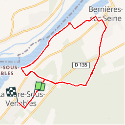
Tocht Stappen van 8,5 km beschikbaar op Normandië, Eure, Les Trois Lacs. Deze tocht wordt voorgesteld door MichelRando7656.
Beschrijving
Beaux sentiers en campagne et par la forêt. Une bonne partie le long de l'eau.
Foto's

Plaatsbepaling
Land:
France
Regio :
Normandië
Departement/Provincie :
Eure
Gemeente :
Les Trois Lacs
Locatie:
Unknown
Vertrek:(Dec)
Vertrek:(UTM)
377230 ; 5452571 (31U) N.
Opmerkingen